17th & 18th Century Architecture Along the Patuxent River, MD
Essay by Sara Rivers Cofield, 2007
Ashcomb's Quarter
Around the same time as Patuxent Point’s inhabitants abandoned the site, Ashcomb’s Quarter was constructed about a third of a mile to the south. Diagnostic artifacts and historical research point to an occupation that occurred at some point between 1684 and 1730. Though historical documents are few, they indicate that the tract most likely had an absentee owner during this period, Charles Ashcomb, who referred to the tract as “My Quarter” in his 1702 will (Catts et. al. 1999). It is unknown who the inhabitants were at Ashcomb’s Quarter, but the use of the term “quarter” in the 18th century generally implied the presence of an overseer and slaves rather than a tenant occupied site which would have been called “tenement” (Wells 1987:4228-4229). At a quarter, an overseer supervised slaves, but was dependent upon the owner for decision-making and accountable for profits. By contrast, at a tenement, occupants acted much like independent landholders as long as they paid the annual rent in the form of cash, tobacco, or other crops. Although he lived on Maryland’s Eastern Shore, Ashcomb owned numerous African slaves, so it is plausible that some of them were living at Ashcomb’s Quarter under the supervision of an overseer (Wells 1987).
Phase III investigations were initiated at Ashcomb’s Quarter prior to a proposed development project at the Navy’s Solomon’s Naval Recreation Center. Plowzone was sampled, and three areas were mechanically stripped to expose subsurface features. The development project was scrapped when excavations uncovered a prehistoric grave. The features that were not uncovered are therefore still intact and have potential for future research.
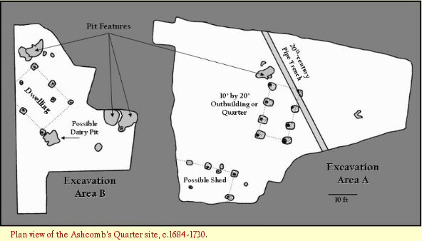
Before the project ended, however, portions of at least three earthfast buildings were exposed, including a three bay outbuilding or quarter measuring about 10’ by 20’, a possible shed of unknown dimensions, and a two-bay probable dwelling measuring about 18’ by 15’ (Catts et. al. 1999). The possible dwelling was interpreted as a shed with a dairy by the authors of the report, but there is evidence of a hearth and the proximity to the dairy and several nearby trash-filled pits fits well with patterns for dwellings at other sites such as King’s Reach (below). The 10’ by 20’ structure is listed in the report as a tobacco house, but the dimensions are simply too small to support this interpretation (Henry Miller and Garry Wheeler Stone, personal communication 2006).

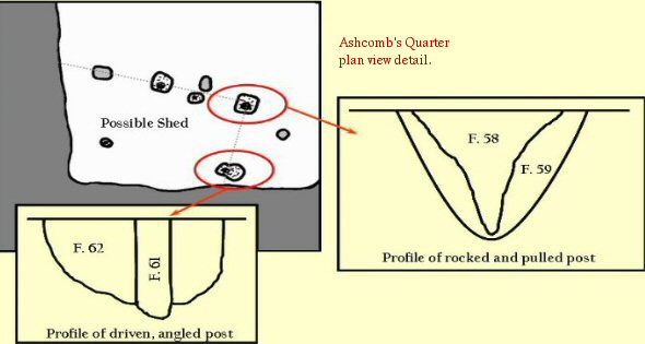
At least two postholes from each building were excavated and none had artifacts other than a few nails or prehistoric materials, so all three structures appear to have been erected within a very short time after the site was first occupied. Stepped postholes indicate sidewall construction for both the 10’ by 20’ outbuilding and the dwelling. Not enough of the shed has been exposed to make a definitive determination about its construction, though one of the posts shows evidence of rocking and pulling, and this is the only structure that incorporates posts with angled, slightly driven bottoms. It is clear that this structure was not as formalized as the other two, supporting its interpretation as an outbuilding such as a shed.

If you have any questions or comments about this article, or sites and artifact collections discussed, please contact:
[email protected].